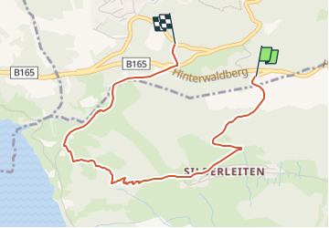
![](/images/other/stat-length.png)
![Tocht Te voet Gemeinde Wald im Pinzgau - Zillertal Arena Runde 5 - Photo](https://media.geolcdn.com/t/1900/400/f53a3632-0e52-4fb3-a3c9-cc316b55954a.jpeg&format=pjpeg&maxdim=2)
Zillertal Arena Runde 5
SityTrail - itinéraires balisés pédestres
Tous les sentiers balisés d’Europe GUIDE+
![Lengte](/images/other/stat-length.png)
![Max. hoogte](https://static1.geolcdn.com/siteimages/upload/files/1508320355ic_sort_altitude_max_24dp.png)
![Positief hoogteverschil](https://static1.geolcdn.com/siteimages/upload/files/1508320355ic_sort_den_pos_24dp.png)
![Km-Effort](/images/other/stat-length.png)
![Min. hoogte](https://static1.geolcdn.com/siteimages/upload/files/1508320355ic_sort_altitude_min_24dp.png)
![Negatief hoogteverschil](https://static1.geolcdn.com/siteimages/upload/files/1508320355ic_sort_den_neg_24dp.png)
![Boucle](https://static1.geolcdn.com/siteimages/upload/files/16400158638029165_repeat_loop_refresh_sync_direction_icon.png)
![Te voet](https://static1.geolcdn.com/sitytour/trail-icons/100.png)
1h29
Moeilijkheid : Gemakkelijk
![Scan deze QR-code om de tocht te openen in de SityTrail-applicatie](https://capi.geolives.com/qq0zvz2zws4bq2lad0pu/sitytour/trails/3128012/qr.png?size=200)
Gratisgps-wandelapplicatie
Over ons
Tocht Te voet van 3,8 km beschikbaar op Salzburg, Bezirk Zell am See, Gemeinde Wald im Pinzgau. Deze tocht wordt voorgesteld door SityTrail - itinéraires balisés pédestres.
Beschrijving
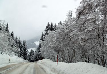
Symbol: Weiße Blechschilder mit grünem oberen Rand mit der Aufschrift "Nature.Fitness Park Nordic Walking". In der Mitte ein schwarzem Punkt mit weißem Richtungspfeil. Rotes Viereck mit weißer Zahl am unteren Rand.
Plaatsbepaling
Opmerkingen
Wandeltochten in de omgeving
![Tocht Te voet Gemeinde Wald im Pinzgau - Zillertal Arena Runde 6 - Photo](https://media.geolcdn.com/t/375/260/f53a3632-0e52-4fb3-a3c9-cc316b55954a.jpeg&format=jpg&maxdim=2)
![Te voet Te voet](https://static1.geolcdn.com/sitytour/trail-icons/100.png)
Te voet
![](/images/other/stat-length.png)
![](https://static1.geolcdn.com/siteimages/upload/files/16400158638029165_repeat_loop_refresh_sync_direction_icon.png)
![Tocht Te voet Krimml - Stauseerunde - Photo](https://media.geolcdn.com/t/375/260/05162670-e071-43c9-9bce-f2b128549ade.jpeg&format=jpg&maxdim=2)
![Te voet Te voet](https://static1.geolcdn.com/sitytour/trail-icons/100.png)
Te voet
![](/images/other/stat-length.png)
![](https://static1.geolcdn.com/siteimages/upload/files/16400158638029165_repeat_loop_refresh_sync_direction_icon.png)
![Tocht Te voet Gemeinde Gerlos - Innertal-Runde - Photo](https://media.geolcdn.com/t/375/260/70c476f7-e8d3-4b76-a1cb-9a4ae4ca99a5.jpeg&format=jpg&maxdim=2)
![Te voet Te voet](https://static1.geolcdn.com/sitytour/trail-icons/100.png)
Te voet
![](/images/other/stat-length.png)
![](https://static1.geolcdn.com/siteimages/upload/files/16400158638029165_repeat_loop_refresh_sync_direction_icon.png)
![Tocht Te voet Krimml - 2-Seen-Runde - Photo](https://media.geolcdn.com/t/375/260/05162670-e071-43c9-9bce-f2b128549ade.jpeg&format=jpg&maxdim=2)
![Te voet Te voet](https://static1.geolcdn.com/sitytour/trail-icons/100.png)
Te voet
![](/images/other/stat-length.png)
![](https://static1.geolcdn.com/siteimages/upload/files/16400158638029165_repeat_loop_refresh_sync_direction_icon.png)
![Tocht Te voet Gemeinde Wald im Pinzgau - Wanderweg 165 - Wald/Königsleiten - Photo](https://media.geolcdn.com/t/375/260/f19ba1db-60c4-4775-8459-e3d3d98a701c.jpeg&format=jpg&maxdim=2)
![Te voet Te voet](https://static1.geolcdn.com/sitytour/trail-icons/100.png)
Te voet
![](/images/other/stat-length.png)
![](https://static1.geolcdn.com/siteimages/upload/files/16400158638029165_repeat_loop_refresh_sync_direction_icon.png)
![Tocht Te voet Krimml - Krimmler Wasserfälle Rundwanderweg - Photo](https://media.geolcdn.com/t/375/260/46a143e4-e5b6-40c1-912c-7eedc375993f.jpeg&format=jpg&maxdim=2)
![Te voet Te voet](https://static1.geolcdn.com/sitytour/trail-icons/100.png)
Te voet
![](/images/other/stat-length.png)
![](https://static1.geolcdn.com/siteimages/upload/files/16400158638029165_repeat_loop_refresh_sync_direction_icon.png)
![Tocht Stappen Krimml - Krimml Waterfalls - Photo](https://media.geolcdn.com/t/375/260/f1f805fd-1700-4ad5-a731-902e6dc9179b.jpg&format=jpg&maxdim=2)
![Stappen Stappen](https://static1.geolcdn.com/sitytour/trail-icons/101.png)
Stappen
![](/images/other/stat-length.png)
![](https://static1.geolcdn.com/siteimages/upload/files/16400158638029165_repeat_loop_refresh_sync_direction_icon.png)
![Tocht Te voet Gemeinde Wald im Pinzgau - Wanderweg 734 - Oberpinzgau - Photo](https://media.geolcdn.com/t/375/260/ext.jpg?maxdim=2&url=https%3A%2F%2Fstatic1.geolcdn.com%2Fsiteimages%2Fupload%2Ffiles%2F1545311037marcheuse_200dpi.jpg)
![Te voet Te voet](https://static1.geolcdn.com/sitytour/trail-icons/100.png)
Te voet
![](/images/other/stat-length.png)
![](https://static1.geolcdn.com/siteimages/upload/files/16400158638029165_repeat_loop_refresh_sync_direction_icon.png)
![Tocht Te voet Gemeinde Wald im Pinzgau - Wanderweg 731 - Oberpinzgau - Photo](https://media.geolcdn.com/t/375/260/ext.jpg?maxdim=2&url=https%3A%2F%2Fstatic1.geolcdn.com%2Fsiteimages%2Fupload%2Ffiles%2F1545311037marcheuse_200dpi.jpg)
![Te voet Te voet](https://static1.geolcdn.com/sitytour/trail-icons/100.png)
Te voet
![](/images/other/stat-length.png)
![](https://static1.geolcdn.com/siteimages/upload/files/16400158638029165_repeat_loop_refresh_sync_direction_icon.png)